
oceanDTM Ltd. 8263439 Registered in England and Wales. Registered office: Riverside Business Centre, Riverside Road, Lowestoft, Suffolk, NR33 0TQ

Marine exploration
In a world where you can instantly view satellite images and even photographs of your own street (just click on the marker on the map to the right) our seas remain an unmapped mystery.
Less than 10% of the UKs’ underwater landscape has been mapped with modern techniques. The need to manage our marine environment has never been greater and we aim to support the improved understanding of the marine environment through better information.
Support based on experience
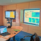
We aim to help you achieve your goals with innovative hardware and software. Whether it be mapping past glacial environments or high resolution survey work, oceanDTM has the expertise to meet your needs.
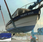
At oceanDTM we have been running our own demonstration vessel “Night Star” for several years, testing out all aspects of the Olex software and WASSP hardware from mapping fish schools in 3D to tracking the changes in the sandbanks around Lowestoft.
On-
oceanDTM demo boat
| Olex Research Vessels |
| Olex Data |
| Olex videos |
| Latest WASSP Install |
| WASSP Data Gallery |
| WASSP Accident Survey |
| WASSP Install Examples |
| Complete WASSP System |
| WASSP Videos |